Color Code Command
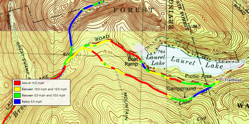
The Color Code command allows you to visualize speed, elevation, heart rate, grade, temperature, depth, or cadence for a tracklog you have recorded with your GPS, fitness watch, or chartplotter. It allows you to create four color bands representing four ranges of measurement data for the track. You can preview the grade change on a hike or ride, see elevation bands on an aerial photo, or analyze temperature or depth changes in your fishing data.
A check mark on the menu indicates that the item is being Color Coded:
 Color Code - the track is drawn with the current Color Code settings.
 Color Code - the track is drawn normally.
To Color Code a track, do the following:
- Select one or more tracks on the map or in the Track List
- Then, do one of the following:
- On the , click Color Code.
- Right-click on the selected track, and click Color Code.
- On the , click
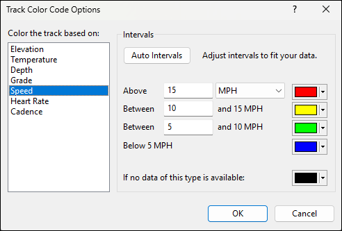
In the Track Color Code Options dialog, select the parameter you would like to measure and color: Elevation, Temperature, Depth, Grade, Speed, Heart Rate, Cadence. Obviously, your tracklog will have to have been recorded with this information on your GPS receiver, chartplotter, or fitness watch.
You can enter your preferred intervals between measurement bands, or click Auto Intervals to have ExpertGPS analyze your track and choose a measurement range that works well for the high and low values in your tracklog data.
As you make changes in the dialog, the map will automatically refresh to show the updated color bands. Click OK when you have the color bands adjusted to your liking.
When you are finished visualizing the color-coded track, do the following:
- Select one or more color-coded tracks on the map or in the Track List
- Then, do one of the following:
- On the , click Color Code.
- Right-click on the selected item, and click Color Code.
- On the , click
The selected items will be drawn normally.
Related Topics
© 1998-2025 TopoGrafix – 24 Kirkland Dr, Stow, MA – Email: support@expertgps.com