Michael T. asks:
![]() How can I use ExpertGPS to survey my property lines?
How can I use ExpertGPS to survey my property lines?![]()
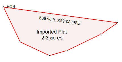
It’s relatively easy to find all of the corners of your property using ExpertGPS. You’ll need a plat, mortgage map, or legal land survey of your property, showing the distance and bearing from each corner to the next. You’ll also need to find ONE corner or monument on your land, to use as a starting point.
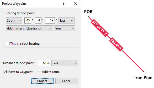
Using your GPS or the mapping tools in ExpertGPS, mark a waypoint at the starting corner that you’ve located on your property. In ExpertGPS, right-click on the starting waypoint, and click Project Waypoint. This will bring up the Project Waypoint dialog, where you’ll enter the distance and bearing of each call in your survey map. ExpertGPS allows you to enter bearings in True or Magnetic degrees, or aligned to a UTM, state plane, or national coordinate grid. You can also enter a custom declination, which can be extremely useful in entering historical deeds where the magnetic field has drifted over time, or when entering plats with a non-standard basis of bearing.
On the map, you’ll see a red preview line projecting from the starting waypoint. It shows you the property line leading to the next boundary corner, based on the distance and bearing you entered.
Check off the Move to Waypoint and Add to Route boxes. When you click Project, ExpertGPS will create a new waypoint at the property corner, and prompt you for the next call (bearing and distance). Move around the property in this way until you have entered all of the calls.
You can now send the waypoints and route to your GPS, and head out into the field to locate the property corners. Use the Go To command on your GPS to navigate to each waypoint marking the corner of your land.
Please realize that there are limits to the accuracy of your GPS receiver. This technique should get you within a few feet of a property corner and will help you narrow down where to search to find missing survey monuments. To create a legal land survey that you can use for selling property or establishing boundaries, you should consult a licensed land surveyor.
Bearings are most often assumed, based on one line of a section, being a cardinal direction. They are almost never “true”. There are many versions of “North”, geodetic, grid, astronomic, besides magnetic. Magnetic north varies over time (see: https://www.ngdc.noaa.gov/geomag/).
To say that a navigation grade GPS should get one within a few feet of a corner is misleading, as at times it may be much worse. I see 50 feet at times, rare, but it happens.
Tom Arneson, Minnesota licensed Land Surveyor N0 12682
Thanks, Tom!
ExpertGPS now handles assumed basis of bearings and custom declinations, which should make it much easier to enter older plats.
With the introduction of modern GPS units that combine signals from Glonass, Galileo, and US GNSS satellites, the accuracy has gotten much better, and the techniques described above should get you close enough to the spot to find a hidden survey pin. I've had good success using a metal detector to find buried iron rods and pins, after using ExpertGPS and a handheld GPS to get to the search location.