Add Mile Markers Command
The Add Mile Markers draws mileage markers at an interval you specify along the length of a track. You can use it to add temporary distance markers to the selected track on the map, or to create permanent waypoints at intermediate points along the track, which you can then send to your GPS.
To add mileage markers to a track, do the following:
- Select one or more tracks on the map or in the Track List.
- Then, do one of the following:
- On the , click
 Add Mileage Markers to the Track.
 - Right-click on the selected tracks, and click Add Mile Markers.
- On the , click
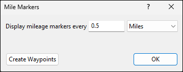
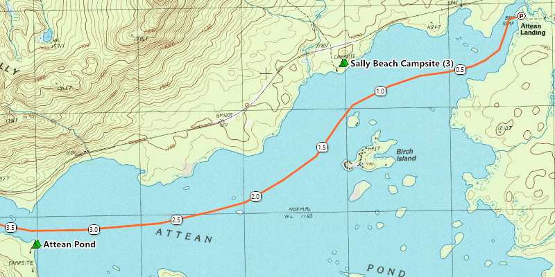
In the Mile Markers dialog, enter the interval at which you would like mileage markers drawn. As you enter a distance, mileage markers will appear on the track on the map inside of a white oval with the distance from the start of the track.
Click OK to add temporary mileage markers to the track. You can remove them later by applying the Add Mile Markers command again to remove the checkmark next to the command.
To create permanent mileage markers as waypoints which you can send to your GPS, click Create Waypoints. This will create a sequence of waypoints of type Mile Marker along the track. You can edit any of the Mile Marker waypoints to change its appearance, and the rest of the mile marker waypoints will update as well.

To turn off temporary mile markers on a track, do the following:
- Select one or more tracks with temporary mile markers on the map or in the Track List
- Then, do one of the following:
- On the , click to remove the checkmark next to
 Add Mileage Markers to the Track.
 - Right-click on the selected item, and click to remove the checkmark next to Add Mile Markers.
- On the , click to remove the checkmark next to
The selected tracks will be drawn normally. You can repeat the command to turn mile markers back on again with different settings.
© 1998-2026 TopoGrafix – 24 Kirkland Dr, Stow, MA – Email: support@expertgps.com