Working with Aerial Photos
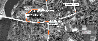
ExpertGPS shows your GPS data on USGS aerial photos, using a UTM projection. As you move around the map, ExpertGPS will retrieve photos over the Internet and display them on your screen. The map server that ExpertGPS uses has aerial photos for most locations in the continental United States. Coverage is not available for much of Alaska, and in some parts of the Mountain West.

Working with Maps
Read about the basic commands for interacting with all of the maps in ExpertGPS.
Showing an Aerial Photo Map
To show an Aerial Photo Map, click on the .
Internet Map Retrieval
To allow ExpertGPS to retrieve aerial photos over your Internet connection, click on the .
ExpertGPS works with hundreds of GPS receivers, including all
Garmin Drive,
nüvi,
eTrex,
Colorado,
Dakota,
echoMAP,
GPSMAP,
Edge,
Forerunner,
Montana,
Oregon, and
Rino models,
Magellan eXplorist GPS receivers, and
Lowrance HDS,
Elite, and
HOOK GPS chartplotters and fishfinders.
Download ExpertGPS
Find your GPS on the ExpertGPS compatibility list.
© 1998-2025 TopoGrafix – 24 Kirkland Dr, Stow, MA – Email: support@expertgps.com


