An ExpertGPS user asks:
![]() When I trace a stream over the map in ExpertGPS, why does ExpertGPS connect the end of my drawn shape back to the beginning?
When I trace a stream over the map in ExpertGPS, why does ExpertGPS connect the end of my drawn shape back to the beginning?![]()
The short answer: because you are drawing with a filled shape type. ExpertGPS allows you to assign a cartographic style to the objects you draw on the map. Every shape, track, and waypoint in ExpertGPS has a Type that you assign. You define the cartographic style (color, line pattern, fill color) for that Type in the Edit Type dialog (the Edit Shape Type dialog is shown below). For Routes, Tracks and Shapes, you can choose a fill pattern. Obviously, only filled objects should have a fill pattern. A lake would have a blue fill. A stream, being a linear object, shouldn’t have any fill. It should just have a blue line color.
Automatic Closing of Filled Shapes
When you draw a new object on the map, and assign it a filled shape type, ExpertGPS automatically closes the shape (by connecting the last point you drew back to the beginning point). Otherwise, you’d end up with lakes with holes in them, and your map would get all wet!
You can manually close any route, shape, or track by selecting it, right-clicking, and clicking Close. To save you this effort, ExpertGPS does it automatically when you assign a filled type to something you’ve just drawn on the map.
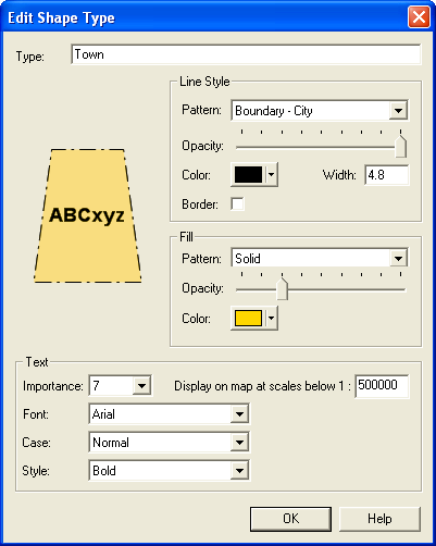
So, if you are tracing the lakes, ponds, streams, and creeks of your area off the topo maps, you should create two Shape Types: Lake and Stream. Lake would have a Solid fill, and Stream would have fill set to None. Choose the Lake type for any body of water (lake, pond, reservoir) and Stream for any linear waterway (stream, creek, canal).
To learn more about the power of ExpertGPS’ cartographic styles and types, read Working with Types in the ExpertGPS Help File.