US National Grid (USNG) Map Overlays and Grid Lines
Al S. asks:
![]() Will ExpertGPS support USNG coordinates and will it show 1Km grids overlayed onto topo maps as a user selection?
Will ExpertGPS support USNG coordinates and will it show 1Km grids overlayed onto topo maps as a user selection?![]()
ExpertGPS supports US National Grid (USNG) coordinates. Click Preferences on the File menu. Click on the My Coordinate Formats tab, and click Add. Change the Location to United States, and select US National Grid, NAD83 datum.
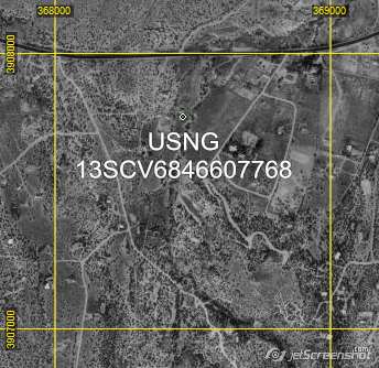
You can enter USNG coordinates in the Edit Waypoint dialog, or import them from a CSV file. As you move the cursor over the map, the USNG coordinates for the cursor location are displayed in the lower right corner of the main ExpertGPS window. You can convert lat/lon, UTM, and state plane coordinates to and from USNG by switching between coordinate formats in the My Coordinate Formats dialog.
ExpertGPS displays a kilometer grid when you are viewing USNG, UTM, state plane, or MGRS coordinates. The interval between grid lines is automatically adjusted based on the map scale. At some scales, you’ll see a 1KM grid spacing, but as you zoom out the spacing will change to 2KM, 5KM, and 10KM to prevent the map from getting obscured by hundreds of grid lines. You can fine-tune the display of grid lines in the Map Display Options dialog. Or, do what I do, and use the < and > keys to remove or add more grid lines on the fly.
If you want to place a waypoint at every kilometer grid intersection, or create a permanent grid overlay at 1KM intervals, try the new Grid Builder tool in ExpertGPS.
Updated on 2020-07-10 by Dan Foster
Did I answer your question completely?
If you still have questions after reading this or the other ExpertGPS tutorials or have a file or a project you need assistance with, please get in touch using the form below, or send the file you're working with to support at expertgps dot com. I'm happy to walk you through how ExpertGPS can handle all of your mapping and data conversion needs.
© 1998-2025 TopoGrafix – 24 Kirkland Dr, Stow, MA – Email: support@expertgps.com