Jim S. asks:
![]() I am with a company that does land planning and golf course design. I have a Garmin rino530hcx and a HP tablet laptop. I can place our plans, jpeg and CAD, in google earth but am stuck with trying to export the plan, with real world coordinates, back to the Garmin.
I am with a company that does land planning and golf course design. I have a Garmin rino530hcx and a HP tablet laptop. I can place our plans, jpeg and CAD, in google earth but am stuck with trying to export the plan, with real world coordinates, back to the Garmin.![]()
What you’re trying to do is to replace the basemap on your GPS with your own GIS and CAD data. Garmin doesn’t provide an official way to do this, and therefore, ExpertGPS doesn’t support it.
There have been programmers in Eastern Europe who have reverse engineered the Garmin basemap (.img) format, and provide software to let you create your own maps. cGPSmapper is one example.
Creating your own Garmin basemap is a fairly complicated process, and you’ll probably want to use a tool like ExpertGPS Pro in addition to cGPSmapper to prepare your CAD and GIS data prior to converting it.
I haven’t used this software before – please let me know what you find if you choose to go this route.
Jim continues:
![]() I think the ultimate goal would be to use the Garmin unit as the antennae and do the GPS work, site recon and way points, on screen in the field.
I think the ultimate goal would be to use the Garmin unit as the antennae and do the GPS work, site recon and way points, on screen in the field.![]()
That’s probably an easier path, and you can do all of this using ExpertGPS Pro and your GPS receiver. ExpertGPS can import (and export) all of your CAD and KML files, and you can use the JPEG files with the scanned maps feature.
You can use the Scanned Maps feature in ExpertGPS to display digital charts, USGS DRGs, or your own scanned paper maps.
The ExpertGPS help file has complete details about preparing and geo-referencing your maps for use within the program.
The Tracking feature in ExpertGPS uses your GPS receiver as an antenna, and turns your laptop into a moving-map GPS display. This would allow you to view your current location over all of your engineering drawings. Having a big color screen and full keyboard, plus the ease of data entry in ExpertGPS, should improve your workflow.
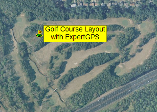
Can you use Garmin Colorado 400t also use for golf course GPS?
I like to use for both trail hiking and golfing if possible,
The Garmin Colorado 400t doesn’t have golf courses built into it, so it won’t know the distance to the pin unless you download a golf course layout in GPX format, or some other format that ExpertGPS can send to your Oregon.
I work at a golf course that was GPSed a few years ago as part to a renovation. I have the data in a CAD file. Can you recommend a hand held GPS that would be good for collecting way points for updating changes made made since the GPS work was done. It also would be nice if the same unit could import the cad file.