Casey from Louisiana asks:
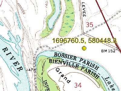
![]() Hi. I am trying to determine a coordinate point location using a property description in an oil and gas lease that was drafted using the Louisiana Coordinate System of 1927. Does your Louisiana North FIPS 1701 mapping system contain the same coordinates as the Louisiana Coordinate System of 1927? My property description uses X and Y coordinates. For example, the coordinates X=1696760.5 and Y=580448.3, using the Louisiana North FIPS 1701 state plane coordinates in your software, delivers a topo map in Oklahoma to my screen – those coordinates should direct me to a map in Bossier Parish, LA. Could you please help me determine where I am going wrong? I believe this software could continue to help my company, but I need to figure out if the software is compatible with my property descriptions. Thanks.
Hi. I am trying to determine a coordinate point location using a property description in an oil and gas lease that was drafted using the Louisiana Coordinate System of 1927. Does your Louisiana North FIPS 1701 mapping system contain the same coordinates as the Louisiana Coordinate System of 1927? My property description uses X and Y coordinates. For example, the coordinates X=1696760.5 and Y=580448.3, using the Louisiana North FIPS 1701 state plane coordinates in your software, delivers a topo map in Oklahoma to my screen – those coordinates should direct me to a map in Bossier Parish, LA. Could you please help me determine where I am going wrong? I believe this software could continue to help my company, but I need to figure out if the software is compatible with my property descriptions. Thanks.![]()
Why don’t these Louisiana Coordinate System of 1927 locations map properly in ExpertGPS?
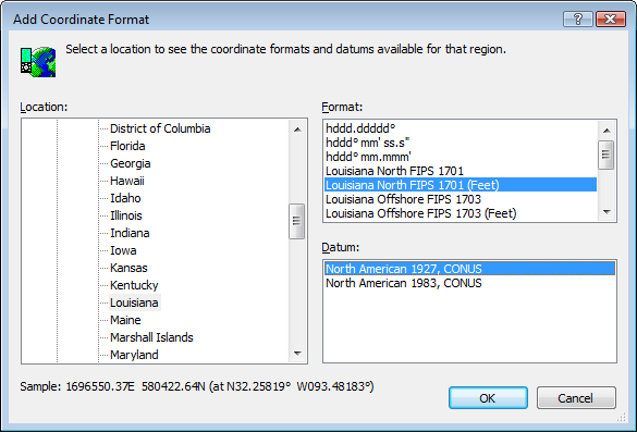
ExpertGPS Pro lists two versions of each State Plane Coordinate System: one in Meters, and one in US Survey Feet. You’ll need to select the correct one for the coordinates you’ll be working with. You’ll also need to know the correct datum (NAD27 or NAD83/WGS84).
As a general rule of thumb, NAD83 State Plane coordinates use meters, and NAD27 coordinates use the US survey foot. That’s the case for your data, given in the Louisiana Coordinate System of 1927. When I selected the “feet” version of the LA North SPCS in ExpertGPS’ Add Coordinate Format dialog, your X,Y coordinates mapped to the correct location in Bossier Parish.