ExpertGPS Pro user Suhail K. asks:
![]() Our small company performs low-altitude, helicopter-based high-definition aerial videologging and photography for historical documentation of environmental, commercial, general municipal, and transportaiton needs. I currently use ESRI’s ArcPad for navigation and data collection along with several Garmin devices. Do you have any plans of translating Garmin gps trails into Point Shp files? Many of our clients need this, so I create points in ArcGIS from X,Y coordinates and a subsequent point file. I would really like to use ExpertGPS for almost everything instead of adding addtional software to my workflow.
Our small company performs low-altitude, helicopter-based high-definition aerial videologging and photography for historical documentation of environmental, commercial, general municipal, and transportaiton needs. I currently use ESRI’s ArcPad for navigation and data collection along with several Garmin devices. Do you have any plans of translating Garmin gps trails into Point Shp files? Many of our clients need this, so I create points in ArcGIS from X,Y coordinates and a subsequent point file. I would really like to use ExpertGPS for almost everything instead of adding addtional software to my workflow.![]()
How can I convert my Garmin tracks to X,Y point shapefiles for ArcGIS?
By default, ExpertGPS Pro exports your Garmin tracklogs as polyline shapefiles. Waypoints are exported as point shapefiles. If we convert your Garmin track into a series of waypoints, you’ll be able to use the Export command in the Waypoint List to save your GPS-recorded data as an ArcView point (X,Y) shapefile.
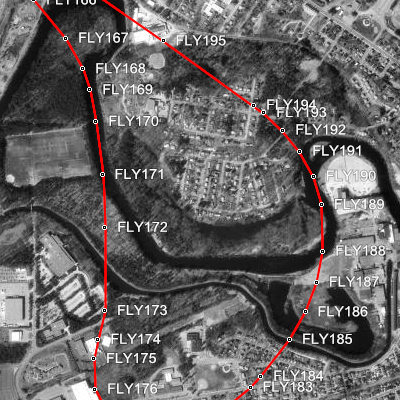
The Convert to Route command in ExpertGPS converts any selected track into a route, creating a waypoint at each point in your GPS tracklog. Before converting your flight track, edit the track and add a short identifier in the Track Name field. I used FLY on my track, so that the Convert to Route command would label the waypoints like this: FLY001, FLY002, FLY003…
Now select the track, right-click, and click Convert to Route. ExpertGPS will convert each trackpoint into a waypoint and string them together into a route. Switch to the Waypoint List and click Export Waypoints in List on the File menu. Change the file type to Point Shapefile (.shp), click OK, and you’re done!