Import, Convert, and Reproject Virginia State Plane Coordinates
ExpertGPS Pro can convert between lat/long, UTM, and any of these state plane coordinate systems used in Virginia. Need to send Virginia state plane coordinates to your GPS? ExpertGPS will transfer Virginia eastings and northings to any Garmin, Magellan, Lowrance, or Eagle GPS receiver. You can import, convert, and reproject GIS shapefiles from ArcMap, DXF CAD files from IntelliCAD and AutoCAD, or bring in X,Y data from any spreadsheet or CSV file. ExpertGPS maps all of your Virginia state plane points and polylines over Virginia topo maps, aerial photos, and your own scanned maps or site plans. Click on any of the links below to get step-by-step help in how to convert Virginia state plane coordinates to lat/lon, UTM, or any other coordinate format, datum, or file format using ExpertGPS Pro.
How to Convert between Virginia State Plane Coordinates, UTM, and Lat/Long
Click on one of the links below for step-by-step tutorials on converting between Virginia northings and eastings and lat/long or UTM coordinates.How to convert Virginia North coordinates in NAD27 datum to and from UTM or lat-lon
How to convert Virginia North coordinates in NAD83 datum to and from UTM or lat-lon
Virginia North FIPS 4501 covers these counties: Alexandria, Arlington, Augusta, Bath, Caroline, Clarke, Culpeper, Fairfax City, Fairfax, Falls Church, Fauquier, Frederick, Fredericksburg, Greene, Harrisonburg, Highland, King George, Loudoun, Madison, Manassas City, Manassas Park City, Orange, Page, Prince William, Rappahannock, Rockingham, Shenandoah, Spotsylvania, Stafford, Staunton, Warren, Waynesboro, Westmoreland, Winchester
How to convert Virginia South coordinates in NAD27 datum to and from UTM or lat-lon
How to convert Virginia South coordinates in NAD83 datum to and from UTM or lat-lon
Virginia South FIPS 4502 covers these counties: Accomack, Albemarle, Alleghany, Amelia, Amherst, Appomattox, Bedford City, Bedford, Bland, Botetourt, Bristol, Brunswick, Buchanan, Buckingham, Buena Vista, Campbell, Carroll, Charles City, Charlotte, Charlottesville, Chesapeake, Chesterfield, Clifton Forge, Colonial Heights, Covington, Craig, Cumberland, Danville, Dickenson, Dinwiddie, Emporia, Essex, Floyd, Fluvanna, Franklin City, Franklin, Galax, Giles, Gloucester, Goochland, Grayson, Greensville, Halifax, Hampton, Hanover, Henrico, Henry, Hopewell, Isle Of Wight, James City, King William, King And Queen, Lancaster, Lee, Lexington, Louisa, Lunenburg, Lynchburg, Martinsville, Mathews, Mecklenburg, Middlesex, Montgomery, Nelson, New Kent, Newport News, Norfolk, Northampton, Northumberland, Norton, Nottoway, Patrick, Petersburg, Pittsylvania, Poquoson City, Portsmouth, Powhatan, Prince Edward, Prince George, Pulaski, Radford, Richmond City, Richmond, Roanoke City, Roanoke, Rockbridge, Russell, Salem, Scott, Smyth, South Boston, Southampton, Suffolk, Surry, Sussex, Tazewell, Virginia Beach, Washington, Williamsburg, Wise, Wythe, York
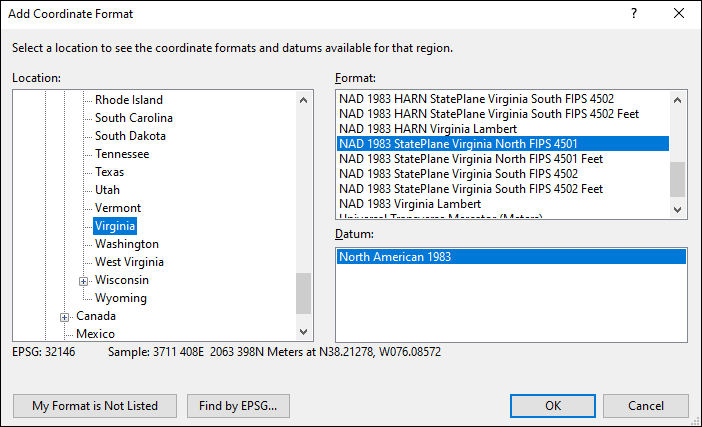
Adding Virginia State Plane Coordinates to ExpertGPS Pro
ExpertGPS Pro can convert between any of the Virginia coordinate formats shown in the Add Coordinate Format dialog below. For complete details and step-by-step instructions on solving the most popular data format and Virginia coordinate conversion problems, click on one of the Virginia State Plane links above.
© 1998-2025 TopoGrafix – 24 Kirkland Dr, Stow, MA – Email: support@expertgps.com