Import, Convert, and Reproject Alaska State Plane Coordinates
ExpertGPS Pro can convert between lat/long, UTM, and any of these state plane coordinate systems used in Alaska. Need to send Alaska state plane coordinates to your GPS? ExpertGPS will transfer Alaska eastings and northings to any Garmin, Magellan, Lowrance, or Eagle GPS receiver. You can import, convert, and reproject GIS shapefiles from ArcMap, DXF CAD files from IntelliCAD and AutoCAD, or bring in X,Y data from any spreadsheet or CSV file. ExpertGPS maps all of your Alaska state plane points and polylines over Alaska topo maps, aerial photos, and your own scanned maps or site plans. Click on any of the links below to get step-by-step help in how to convert Alaska state plane coordinates to lat/lon, UTM, or any other coordinate format, datum, or file format using ExpertGPS Pro.
How to Convert between Alaska State Plane Coordinates, UTM, and Lat/Long
Click on one of the links below for step-by-step tutorials on converting between Alaska northings and eastings and lat/long or UTM coordinates.How to convert Alaska 10 coordinates in NAD27 datum to and from UTM or lat-lon
How to convert Alaska 10 coordinates in NAD83 datum to and from UTM or lat-lon
Alaska 10 FIPS 5010 covers these counties: All of the Aleutian Island group lying west and south of Unimak Pass.
How to convert Alaska 2 coordinates in NAD27 datum to and from UTM or lat-lon
How to convert Alaska 2 coordinates in NAD83 datum to and from UTM or lat-lon
Alaska 2 FIPS 5002 covers these counties: That part of Alaska lying between meridians 141°00' and 144°00' west of Greenwich.
How to convert Alaska 3 coordinates in NAD27 datum to and from UTM or lat-lon
How to convert Alaska 3 coordinates in NAD83 datum to and from UTM or lat-lon
Alaska 3 FIPS 5003 covers these counties: That part of Alaska lying between meridians 144°00' and 148°00' west of Greenwich and in addition all of Perry Island and all of Esther Island, but excluding all of Latouche Island, all of Evans Island, and all of the Kenai Peninsula.
How to convert Alaska 4 coordinates in NAD27 datum to and from UTM or lat-lon
How to convert Alaska 4 coordinates in NAD83 datum to and from UTM or lat-lon
Alaska 4 FIPS 5004 covers these counties: That part of Alaska lying between meridians 148°00' and 152°00' west of Greenwich and in addition all of Latouche Island, all of Evans Island, and all of the Kenai Peninsula, but excluding Marmot Island, all of Afognak Island, all of the Barren Islands, all of Kalgin Island, all of Perry Island, and all of Esther Island.
How to convert Alaska 5 coordinates in NAD27 datum to and from UTM or lat-lon
How to convert Alaska 5 coordinates in NAD83 datum to and from UTM or lat-lon
Alaska 5 FIPS 5005 covers these counties: That part of Alaska lying between meridians 152°00' and 156°00' west of Greenwich and in addition Marmot Island, all of Afognak Island, all of the Barren Islands, and all of Kalgin Island.
How to convert Alaska 6 coordinates in NAD27 datum to and from UTM or lat-lon
How to convert Alaska 6 coordinates in NAD83 datum to and from UTM or lat-lon
Alaska 6 FIPS 5006 covers these counties: That part of Alaska lying between meridians 156°00' and 160°00' west of Greenwich and in addition Andronica Island and all of Nagai Island.
How to convert Alaska 7 coordinates in NAD27 datum to and from UTM or lat-lon
How to convert Alaska 7 coordinates in NAD83 datum to and from UTM or lat-lon
Alaska 7 FIPS 5007 covers these counties: That part of Alaska lying between meridians 160°00' and 164°00' west of Greenwich and in addition all of Unimak Island, but excluding Andronica Island and all of Nagai Island.
How to convert Alaska 8 coordinates in NAD27 datum to and from UTM or lat-lon
How to convert Alaska 8 coordinates in NAD83 datum to and from UTM or lat-lon
Alaska 8 FIPS 5008 covers these counties: That part of Alaska lying between meridians 164°00' and 168°00' west of Greenwich and in addition King Island, Little Diomede Island, and all of Cape Prince of Wales, but excluding all of the Aleutian Islands.
How to convert Alaska 9 coordinates in NAD27 datum to and from UTM or lat-lon
How to convert Alaska 9 coordinates in NAD83 datum to and from UTM or lat-lon
Alaska 9 FIPS 5009 covers these counties: All islands in the Bering Sea lying west of meridian 168°00' west of Greenwich, excluding all of the Aleutian Islands, King Island, and Little Diomede Island.
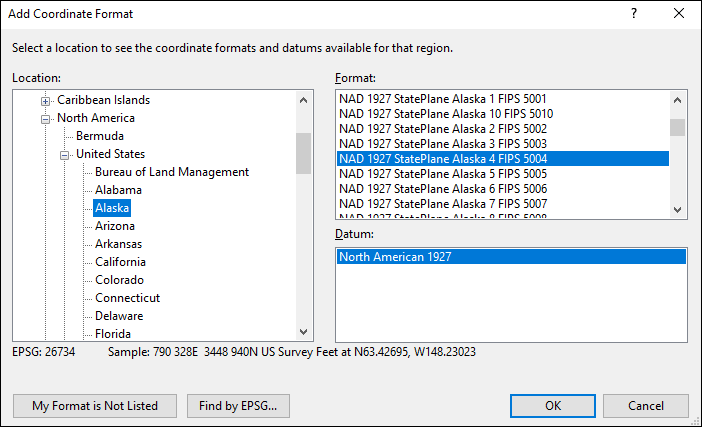
Adding Alaska State Plane Coordinates to ExpertGPS Pro
ExpertGPS Pro can convert between any of the Alaska coordinate formats shown in the Add Coordinate Format dialog below. For complete details and step-by-step instructions on solving the most popular data format and Alaska coordinate conversion problems, click on one of the Alaska State Plane links above.
© 1998-2025 TopoGrafix – 24 Kirkland Dr, Stow, MA – Email: support@expertgps.com