Creating Grids on a Map with ExpertGPS
ExpertGPS Pro includes a powerful Grid Builder feature that allows you to instantly create a grid of waypoints, regularly-spaced out along a baseline you specify. Use the Grid Builder tool to break a parcel down into 1 acre patches, or to create a "fishnet grid" of points to visit on your next timber cruise. Place a grid over a lake or pond to create a mesh of water-quality, depth, or temperature sampling points. Break down a PLSS township into sections and quarter sections.
Calculate the Area of any Parcel with ExpertGPS

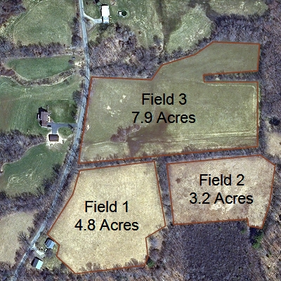
Just a few clicks on the aerial photos in ExpertGPS was all that it took to trace these fields. ExpertGPS automatically calculates the area for any drawn object on the map, or for your recorded GPS tracklogs.
Calculate Area and Display in:
- Acres
- Square Miles
- Square Feet
- Hectares
- Square Kilometers
- Square Meters
Related Topics
Step-by-step instructions on using the Grid Builder command to create sampling grids or for timber cruises in forestry.
Ask the GPS Expert: How do I calculate the area of a farm field?
Ask the GPS Expert: How do I determine the acreage of a field covered by a center-pivot irrigator?
ExpertGPS Help File: Calculating Area
New features were added to ExpertGPS on November 7, 2025
ExpertGPS runs on Windows 11 and Windows 10.
Who Uses ExpertGPS?
Forestry / Silviculture - Calculating Area of Timber Tracts
Timber companies use ExpertGPS to calculate the acreage of woodlots and to estimate harvest yields. Foresters can view their holdings on the aerial photo maps in ExpertGPS, and superimpose grids and draw routes prior to field work. Parcel and tract outlines can be sent to any handheld GPS prior to field work. After a timber cruise, you can retrieve the GPS tracklog from your Garmin or Magellan GPS receiver and plot your exact path through the forest on the maps in ExpertGPS. ExpertGPS accurately calculates the acreage of any closed figure you draw on the map, or walk with your GPS.
Precision Agriculture / Farming - Calculating Area of Fields
Calculate field sizes using ExpertGPS to accurately determine fertilizer requirements and to estimate crop yield. Quickly map out fence lines and paddocks, and send a map of your fields right to your GPS. In the field, use your GPS to mark waypoints at locations that need spot treatments. Print out maps of your fields.
Property Management / Real Estate - Calculating Area of Lots and Parcels
Calculate the acreage of any lot or commercial parcel. Preview any site right from your computer - just enter the address, and ExpertGPS brings up the map. Determine property boundaries by entering the legal description (metes and bounds) into ExpertGPS. Print out parcel maps to distribute to clients.
Whatever your job, if you work with land, GPS, or maps, you'll benefit from ExpertGPS mapping software. Download the free trial and put ExpertGPS to work for you.
New features were added to ExpertGPS on November 7, 2025
ExpertGPS runs on Windows 11 and Windows 10.
![]() ExpertGPS is probably the best investment I've ever made in software. Every time I think I know it all, I find some other really useful feature that I never knew existed.
ExpertGPS is probably the best investment I've ever made in software. Every time I think I know it all, I find some other really useful feature that I never knew existed.![]() Alex Mottram
Alex Mottram
Partial Client List:
- Plum Creek Timber Co.
- US Geological Survey
- Pennington Seed
- Peters Forest Resources
- US Fish & Wildlife Service
- Bureau of Land Management
- The Nature Conservancy
- Army Corps of Engineers
- US Forest Service
- Environmental Management Services, Inc
- Taiga Consultants
- Northern Hardwoods
- LPG Environmental
- and many more...
© 1998-2025 TopoGrafix – 24 Kirkland Dr, Stow, MA – Email: support@expertgps.com
