Calculating Area and Acreage with a GPS Receiver
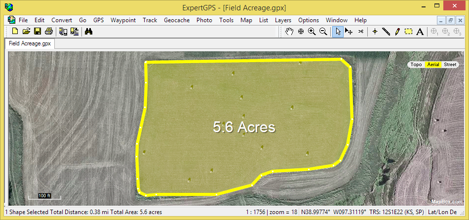
Accurately calculating the area of irregular parcels, fields, and other geographic features is an important task for real estate agents, foresters, and property owners. ExpertGPS mapping software makes it easy to calculate area, no matter how irregular the boundary. If you can walk the property with a GPS receiver, or trace it on a map or aerial photo, ExpertGPS can calculate the area, and display the results in acres, square feet, square miles, hectares, or square kilometers.
We apply a fertilizer material for local farms and ranches and we charge them by the acre. This program allows us to outline the field and determine the acreage that should be charged.
New features were added to ExpertGPS on May 1, 2026
ExpertGPS runs on Windows 11 and Windows 10.
Related Topics
- Ask the GPS Expert: Calculating the coverage of a central-pivot irrigator
- Ask the GPS Expert: How do I calculate the area of a farm field?
- ExpertGPS Help File: Calculating Area
Who Uses ExpertGPS?
I'm going to use ExpertGPS for mapping my crop land for reporting my acres to FSA and federal crop insurance.
Forestry / Silviculture - Calculating Area of Timber Tracts
Timber companies use ExpertGPS to calculate the acreage of woodlots and to estimate harvest yields. Foresters can view their holdings on the aerial photo maps in ExpertGPS, and superimpose grids and draw routes prior to field work. Parcel and tract outlines can be sent to any handheld GPS prior to field work. After a timber cruise, you can retrieve the GPS tracklog from your Garmin or Magellan GPS receiver and plot your exact path through the forest on the maps in ExpertGPS. ExpertGPS accurately calculates the acreage of any closed figure you draw on the map, or walk with your GPS.
Precision Agriculture / Farming - Calculating Area of Fields
Calculate field sizes using ExpertGPS to accurately determine fertilizer requirements and to estimate crop yield. Quickly map out fence lines and paddocks, and send a map of your fields right to your GPS. In the field, use your GPS to mark waypoints at locations that need spot treatments. Print out maps of your fields.
Property Management / Real Estate - Calculating Area of Lots and Parcels
Calculate the acreage of any lot or commercial parcel. Preview any site right from your computer - just enter the address, and ExpertGPS brings up the map. Determine property boundaries by entering the legal description (metes and bounds) into ExpertGPS. Print out parcel maps to distribute to clients.
Whatever your job, if you work with land, GPS, or maps, ExpertGPS will save you time and money. Put ExpertGPS to work for you.
© 1998-2026 TopoGrafix – 24 Kirkland Dr, Stow, MA – Email: support@expertgps.com