Download, Map, and Convert Your Data with ExpertGPS
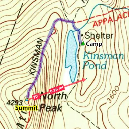
ExpertGPS On the Trail
- Download scanned USGS 1:24K topo maps.
- Connect your GPS and see how far, how fast you went.
- Draw trails directly on maps and send to your GPS.
- Your photos appear exactly where you took them.
- ExpertGPS Home: $33/yr
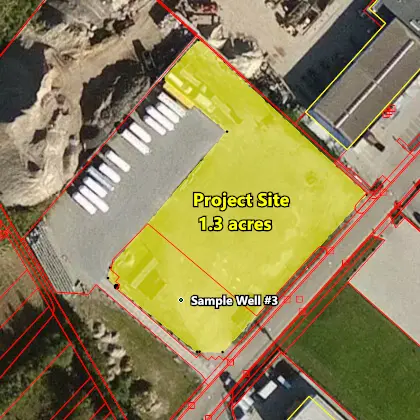
ExpertGPS On the Job
- Combine CAD, GIS and GPS data over any map.
- Measure distance. Calculate area. Locate parcels.
- Convert lat/lon, UTM, and state plane coordinates.
- Pull up maps for any address to pre-plan site visits.
- ExpertGPS Pro: $79/yr
ExpertGPS is the ultimate GPS map software for planning outdoor adventures. View GPS waypoints and tracklogs from any handheld GPS receiver over aerial photos and US topographic maps. Plan your next outdoor adventure over scanned USGS topo maps and send a route directly to your GPS receiver to guide you in the field. View your GPS tracklog over an aerial photo to see exactly where you went.
ExpertGPS handles all your mapping and data-conversion jobs. You'll be able to convert any GPS, GIS, or CAD data to or from GPX, Google Earth KML or KMZ, Excel CSV or TXT, SHP shapefiles, or AutoCAD DXF drawings in two clicks. You can reproject data in any geographic format (lat-lon, UTM, US State Plane) and change datums instantly. With ExpertGPS, you'll be able to calculate acreage, measure distance, elevation and grade.
Download a Free Trial of ExpertGPS Map Software
New features were added to ExpertGPS on April 15, 2024
ExpertGPS runs on Windows 11 and Windows 10.
ExpertGPS downloads worldwide aerial photos and street maps, USGS topo maps, and NOAA nautical charts, saving the maps to your hard drive for offline use. Disconnect your laptop and head out on a trip, and all of your data is available.
Whether you're discovering a new trail or scouting a 400 acre parcel, ExpertGPS gives you the maps and tools you need to get the job done. No other software makes it this easy to add your GPS, CAD, GIS, and photo data to maps and aerial photos.
Download a free trial of ExpertGPS, or purchase your copy today!
© 1998-2024 TopoGrafix – 24 Kirkland Dr, Stow, MA – Email: support@expertgps.com