Jim D. asks:
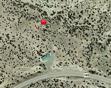
![]() Hi, I have and love expertGPS. I’ve been asked to layout a corner or two for our Placitas Volunteer Library for ground breaking next Sunday. The surveyor of the building sent me, for example, x=1578443.56 y=1567807.68 nad 83, central new mexico, he tells me these are in feet from the principle meridian and baseline. I just want to use my gps, garmin 76 cs to roughly mark a corner or two. Can the expertGPS pro do this, convert to utm’s, or lat/long.
Hi, I have and love expertGPS. I’ve been asked to layout a corner or two for our Placitas Volunteer Library for ground breaking next Sunday. The surveyor of the building sent me, for example, x=1578443.56 y=1567807.68 nad 83, central new mexico, he tells me these are in feet from the principle meridian and baseline. I just want to use my gps, garmin 76 cs to roughly mark a corner or two. Can the expertGPS pro do this, convert to utm’s, or lat/long.![]()
ExpertGPS Pro (not ExpertGPS Home) supports all of the US state plane coordinate system formats, and will allow you to enter X,Y data in meters or feet and convert these to lat/lon or send them to your GPS.
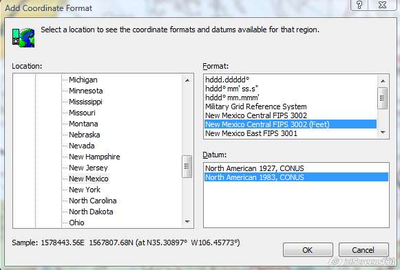
To locate the site of your library, I first selected the NM Central NAD83 state plane coordinate system in the My Coordinate Formats tab in ExpertGPS Pro. Do this by clicking Preferences on the Edit menu. Since your surveyor gave you X,Y coordinates that are in US Survey Feet, not Meters, select the second NM Central SPCS entry, the one marked (feet).
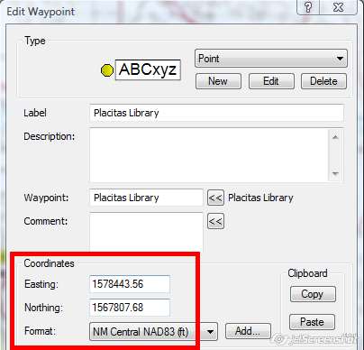
Now when you add a new waypoint, you’ll be able to enter the coordinates as Eastings and Northings (X,Y) rather than Latitudes and Longitudes. The drop-down list marked Format: lists all of the coordinate format’s you’ve chosen to work with, and so you can now switch back and forth between UTM, lat/lon, and NM Central NAD83 with just a single click. Any time you change the active coordinate format, ExpertGPS Pro will instantly reproject all of your data to the new coordinate format.
To view your newly-marked waypoint in the field, just click Send to GPS. Even though your Garmin GPS can’t display NM state plane coordinates directly, you’ll still be taken to the right spot. ExpertGPS always communicates with your GPS using WGS84 latitude and longitude, regardless of the display formats and datums you’ve selected in ExpertGPS or on your GPS receiver.
Related Topics
How to Convert Coordinates between Latitude/Longitude and the State Plane Coordinate System
Details on all State Plane Coordinate Systems in ExpertGPS Pro