Jani asks:
![]() If we are using e.g. Lowrance LCX series plotters, can we export depth data as well as coordinates? Or is this something we can do (to a text file) with Lowrance’s own software?
If we are using e.g. Lowrance LCX series plotters, can we export depth data as well as coordinates? Or is this something we can do (to a text file) with Lowrance’s own software?![]()
Your Lowrance LCX-series GPS chartplotter records depth data along with GPS coordinates, and ExpertGPS can extract the depth information from your chartplotter and display it, or convert it to text, CSV, KML, or other formats, so you can use it in any program you like.
Lowrance GPS receivers and chartplotters store user data (waypoints, routes, and tracklogs with depth info) in .USR files. You’ll need a USB card reader attached to your computer. Remove the data card from your chartplotter, place it in the card reader, and then click Receive from GPS in ExpertGPS. ExpertGPS will prompt you for the location of the .USR file you’d like to download from your GPS receiver’s data card.
To view the depth or elevation data associated with your chartplotter’s recorded tracks, switch to the Track List in ExpertGPS. Select a track, and click Show Elevation Profile on the Track menu.
Exporting Lowrance GPS Depth and Elevation to an Excel Spreadsheet
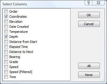
If you’d like to export the depth information to Excel or another program in text or CSV format, select a track, and click Show Trackpoint List on the Track menu. This will bring up a list of every data point in the recorded GPS track, showing the exact coordinates of each point, and other columns of information. The Depth column is hidden by default. To enable it, click Select Columns on the List menu, and place a check mark next to the Depth column. You can now select the entire Trackpoint List, Copy, and Paste directly into a spreadsheet.
Viewing the GPS Track from your Lowrance Chartplotter in Google Earth
Another useful tool is the View in Google Earth command on the Go menu. Simply click the command or press F7 to view your recorded GPS tracks and waypoints over the aerial imagery and underwater contours of Google Earth.
why does GPS don’t show elevation of each coodinate after track?
Most Garmin GPS receivers only store elevation
data for the Active Tracklog, not for tracks saved on the GPS.
If you don’t have elevation data from the GPS, you can use ExpertGPS
to add it.